|
|
Mississippi State University Campus Bus Networking:
A Real-Time Vehicle Monitoring Testbed
Over the next five to ten years, transportation systems will
transition from manually-operated systems in which traffic flow is
controlled by human operators residing at a central location, to
autonomous intelligent systems that react to events in real-time
before humans can intervene.
Highway deaths continue to rise
and have become
a leading cause of death worldwide.
Worse yet, deaths are expected to grow exponentially as third world
countries become increasingly industrialized. In addition to these
sober statistics, increasing traffic congestion in major
metropolitan areas robs Americans of time and money, and is a major
source of environmental, health, and economic development problems.

|
Networked vehicles that perform collaborative problem-solving will
be a cornerstone of the next generation Intelligent Transportation
System (ITS). The
U.S. Department of Transportation's (USDOT) Intelligent
Transportation Systems (ITS) program
has launched a new generation of initiatives aimed at improving
transportation safety, relieving congestion and enhancing
productivity. Automotive companies are creating a new generation of
vehicles that integrate personal computing, the Internet, and
wireless communications. Integrating Global Positioning Satellite
(GPS) navigation systems with online road and city maps enables
drivers to easily find their way or locate hotels, restaurants, and
gas stations in the area. A wireless peer-to-peer networking system
enables cars to exchange information or forward Internet data to the
nearest wireless base station. Together the automotive companies are
interfacing in-vehicle data acquisition and telematics systems with
global telecommunications infrastructures to provide a portfolio of
diagnostic services for the transportation/automotive market.

|
Telematics provides a convergence of electronic technologies and
embedded processing for automotive diagnostics, control,
entertainment, cellular communication, ubiquitous computing (e.g.,
Internet, laptops, PDA, computing nodes on wheels), GPS, GIS, and
human interfaces. The main objective of this project is the
development of the hardware and software necessary to perform
two-way communications with a vehicle and to collect critical
vehicle performance and sensing data. This will be accomplished by
integrating existing on-board measurement information available in
most current vehicles through industry-standard interfaces, to new
cellular modem technology that allows high-speed wireless data
connections. This unique data collection capability will be used to
fuel research and evaluation of new alternative power trains.

|
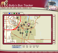
In the first phase of this project, we have developed a system that
will monitor the
Mississippi State University campus bus system.
Bully's
Bus Tracker
is a web-based bus position monitoring system and a vehicle data
acquisition system. In addition to tracking bus position in
real-time using a Global Positioning System (GPS), key engine
parameters such as speed, rpms, temperature, and engine load are
recorded in 1-second intervals, and stored in a database which can
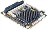
be accessed via the worldwide web. A single-board system is being
developed that integrates chipset solutions for the automotive bus
interface, a GPS receiver, and a cellular telephone modem into a 16
in2 board located inside the dashboard or in the trunk of
a vehicle. In the second phase, we will increase the level of
integration of this system and shrink its size and power
requirements. The system is capable of tracking large numbers of
vehicles and is extensible to large metropolitan areas that contain
millions of vehicles.

|
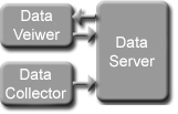
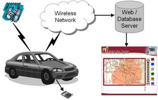
Our networked vehicle system (NVS) is based on
general packet radio service (GPRS) -
a global system for mobile communications (GSM) based Internet
application. NVS's modular architecture is shown above, and can
support a variety of communications services. CBN is an NVS
application that consists of an automatic vehicle tracking system
(AVL) integrated with a vehicle performance data acquisition
system. The in-vehicle networking and data collection platform
(IVNDS) incorporates a GPS receiver, an on-board diagnostics (OBD
II) interface, and a GSM/GPRS transceiver. In the second phase of
the project, IVNDS will be integrated with the CAN bus and in-car
networking system, such as Bluetooth. This will allow on-board
wireless sensors, such as tire pressure monitors, to be captured. It
will also decrease the cost of introducing such technology into a
vehicle because the need for labor-intensive point-to-point wiring
will be eliminated.
The web-based position monitoring system consists of an interactive
map that displays the real-time location and the routes of each bus.
The operational performance and usage data collected in a real time
mode from these buses and other vehicles will provide a baseline on
vehicle operation while using various hydrocarbon-based fuels. As
alternative power systems and bio-fuels are developed in the various
research programs at MSU and CAVS and used in the operation these
same vehicles, analysis of the overall operation and the resulting
trade-offs between performance, emission and cost can be conducted
and the overall efficiency of the alternative power/fuel options can
be evaluated.
Our vision is to create a world-class web presence for this data
that will establish CAVS as the preeminent site for distribution and
analysis of such data. The addition of advanced sensor capabilities
above and beyond typical vehicle data opens up the possibility of
mobile sensor networks capable of monitoring road conditions,
environmental conditions and infrastructure status. The networked
collaborative vehicle represents a mobile node in a vast network,
closing a gap in ad hoc networks and providing remote roadside
structures the means to communicate with authorities. These same
vehicles to provide a link for peer-to-peer ad hoc networks for
enhanced communication of traffic conditions and advisories.
The Campus Bus Networking project involves the collaboration of the
Transportation Department
,
Information Technology Services Department
, and
GeoResources Institute (GRI)
of Mississippi State University.
|
|